Cendere Bridge: A Timeless Roman Arch
Introduction

The Cendere Bridge (Turkish: Cendere Köprüsü; also Severan, Chabinas, or Septimius Severus Bridge) stands as a testament to Roman engineering prowess in the challenging terrain of ancient Commagene. This well-preserved late Roman single-span ashlar arch, located near Kahta in Adıyaman Province, Turkey, represents one of the most significant examples of Roman bridge construction in the eastern provinces.
Inscriptions attribute construction to Legio XVI Flavia Firma and date the work to the early third century CE during the reign of Septimius Severus, most commonly placed around 200–204 CE. The bridge's siting exploits a narrow gorge crossing and demonstrates sophisticated Roman road engineering in Upper Mesopotamia, supporting the cursus publicus along the eastern frontier road network of Upper Mesopotamia.
Historical and Regional Context
Following Septimius Severus' campaigns against the Parthians, culminating in the capture of Ctesiphon, Rome reorganized the region and consolidated infrastructure, including critical river crossings. The bridge's construction coincided with a period of renewed Roman investment in frontier infrastructure, reflecting the strategic importance of secure communication routes in the eastern provinces.
Epigraphic evidence on the bridge credits the work to Legio XVI Flavia Firma, then based at Samosata on the Euphrates. Dating discussions in the literature propose a span of c. 200–204 CE, reflecting the complexities of imperial titulature recorded in the inscriptions. Nearby landmarks include Arsameia (Eski Kale), Karakuş Tumulus, and the Nemrut Dağ monumental complex (UNESCO World Heritage, ID 448).
Engineering Analysis and Construction


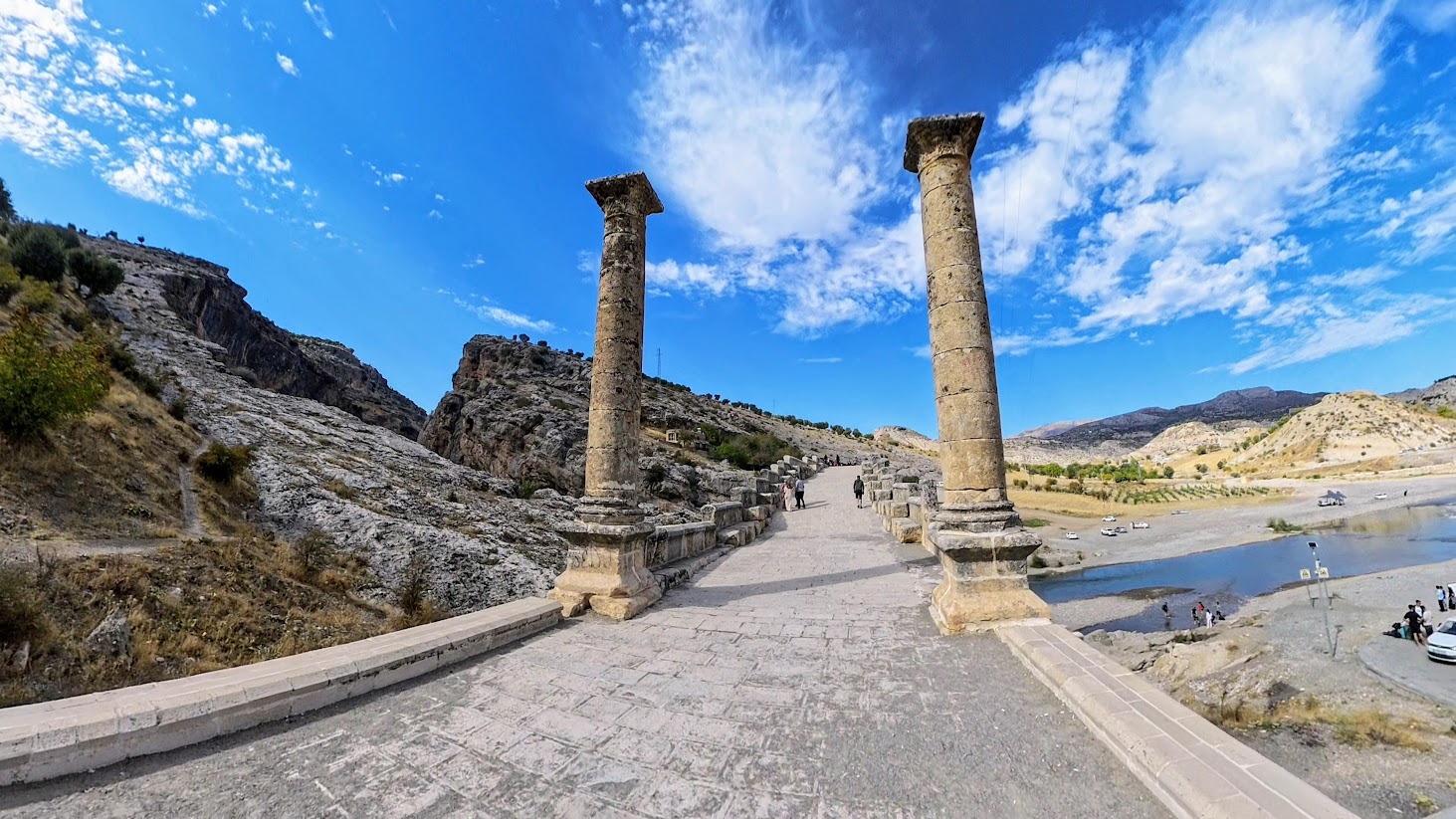
Cendere represents a masterpiece of single-span, semicircular arch construction using large, well-dressed ashlar blocks in apparent dry-laid technique, consistent with Roman practice for permanent river crossings. The deck rises slightly toward midspan (camber) with carefully engineered approach ramps. Several reports mention a small culvert or secondary opening in the south approach for drainage management.
The abutments appear keyed directly into bedrock at the narrowest part of the valley, optimizing both span length and thrust control. For a semicircular arch with span S ≈ 34.2 m, the theoretical rise R ≈ 17.1 m. Under gravity loading, a properly proportioned masonry arch maintains a compression-only state if the line of thrust remains within the middle third of the arch ring.
| Parameter | Measurement | Source References | Notes |
|---|---|---|---|
| Clear Span | ≈34.2 m | [1–3] | Consistent across sources |
| Total Length | ≈118–123 m | [1–3,5] | Varies by survey method |
| Deck Width | ≈7–7.5 m | [1–3,5] | Reported range |
| Theoretical Rise | ≈17.1 m | Calculated | For semicircular arch |
| Construction Date | 200–204 CE | [1–4,9] | Reign of Septimius Severus |
| Current Status | Pedestrian only | [1,3] | Modern bridge 500m east |
Epigraphy and Inscriptions

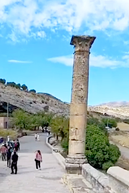
Inscriptional blocks and column dedications record both the imperial family and local civic contributors, creating a comprehensive commemorative program that reflects the bridge's political and strategic significance. Four Corinthian columns originally flanked the approaches, honoring Septimius Severus, Julia Domna, Caracalla, and Geta.

Inscriptions also indicate that four cities of Commagene contributed to the project; scholars commonly list Samosata, Perre, Doliche, and Germanicia as the likely donors, based on local epigraphic and literary traditions. This collaborative funding model reflects the economic integration of Roman provincial administration.
Archaeological Context and Regional Significance

The Cendere Bridge should be understood within the broader archaeological landscape of Roman Commagene, including nearby sites such as Perre (ancient Pirrha), Arsameia, and the royal tomb-sanctuary of Nemrut Dağ. These sites collectively demonstrate the region's importance as a crossroads between Roman, Persian, and Hellenistic cultural traditions.
The bridge spans the Cendere Çayı (Latin: Chabinas/Chabina(s)), a tributary of the Kâhta Creek. The crossing location benefits from constrained channel width and favorable bedrock geometry. The single-arch scheme minimizes in-channel obstructions and reduces risk of debris accumulation during flood events, demonstrating sophisticated hydraulic engineering considerations.
Conservation and Modern Use
The bridge is well documented by travelers and scholars from the 19th and 20th centuries — [ Hogarth 1896; Leaning 1971; O’Connor 1993 ( WorldCat; JRS review; JRA review ); Sinclair 1989 ( Publisher; WorldCat ) ]. The bridge underwent significant conservation work in 1951 and 1997. Vehicular traffic was progressively restricted and is now prohibited; a modern road bridge sits approximately 500 meters to the east. Today, Cendere functions as a pedestrian monument within a protected landscape frequently visited in conjunction with Nemrut Dağ UNESCO World Heritage site itineraries.
Comparative Analysis and Significance

Within the corpus of Roman bridges, Cendere is frequently cited among the largest surviving single-span examples. Broader comparisons typically involve multi-span works such as Alcántara or Mérida, or non-Roman segmental arches from later periods. Given variations in reported metrics across sources and the rarity of large single-span survivals, conservative phrasing is preferred over strict superlatives when making comparative claims.
The bridge's engineering solutions reflect Roman adaptability to local conditions: the narrow gorge setting reduced material demands and vulnerability to scour relative to multi-pier solutions, while the substantial abutment construction demonstrates understanding of thrust management in challenging geological conditions.
Conclusions and Ongoing Research

The Cendere Bridge represents a remarkable synthesis of Roman engineering expertise, imperial commemoration, and regional collaboration in the early third century CE. Its survival provides invaluable insights into Roman construction techniques, provincial administration, and the physical expression of imperial power in frontier territories.
This synthesis reconciles descriptive and metric data reported across multiple scholarly and popular sources, providing a comprehensive overview suitable for both academic reference and public education. The bridge's integration with the Nemrut Dağ cultural landscape ensures its continued significance for understanding Roman provincial culture and engineering legacy.
Terminology
- Ashlar: finely cut and dressed stone blocks laid in regular courses.
- Voussoir: a wedge-shaped stone used to construct an arch.
- Keystone: the central, uppermost voussoir locking the arch ring.
- Line of thrust: the locus of compressive resultants through the arch ring under load.
- Damnatio memoriae: Roman sanction condemning a person's memory, leading to removal of names/images from monuments.
- Legio XVI Flavia Firma: Roman legion stationed at Samosata, responsible for bridge construction.
- Commagene: Hellenistic kingdom annexed by Rome, encompassing the bridge region.
- Semicircular arch: classical Roman arch profile with rise equal to half the span.
Listen in to the Sounds of Roman Anatolia
A short listening tour connecting the Cendere (Severan) Bridge to the sound world of Roman Anatolia and the wider Near East.
Figure Citations and Sources
Audio Citations and Sources
File page: Wikimedia Commons · Direct audio: OGG
File page: Internet Archive · Direct file: WEBM
File page: Wikimedia Commons · Direct audio: OGG
References
This article includes the following interactive elements: a panoramic 360 header image, click‑to‑expand images, and inline Wikipedia links for key terms that open in a new window.
Like to discuss or comment on this article? See my page on Facebook.